UGOVIZZA-FORCELLA NEBRIA BARRIER

Historical background and composition
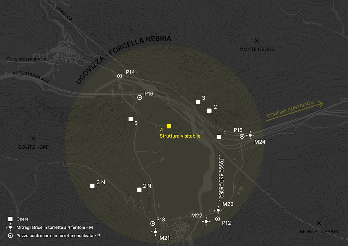
The works that made up the Ugovizza-Forcella Nebria barrier were reactivated by the Alpine Wall barrier of Malborghetto-Valbruna. The latter, built between 1938 and 1942, was divided into four groups of works: Malborghetto, Quota 845, Nebria and Valbruna. During the reactivations of the early 1950s, due to the new defence requirements against the Warsaw Pact troops, it was divided into two distinct barriers: Malborghetto, which included the group of the same name, and Ugovizza-Forcella Nebria, which included the Quota 845 and Nebria groups (the works of the Valbruna group were not reactivated). Of these two groups, seven works were reactivated, to which structural modifications were made to increase their anti-tank capacity and the now ineffective weaponry was replaced. At the end of the reactivation works, this was their composition:
- work 1: it featured four P positions (for anti-tank guns) and six M positions (for machine guns)
- work 2: it featured two M positions;
- work 3: it featured one P position;
- work 4 (structure that can be visited): this work housed the command post of the barrier and featured two P positions and two M positions;
- work 5: it featured two P positions and two M positions;
- work 2N (Nebria): it featured two P positions and one M position;
- work 3N: it featured one P position and two M positions.
In addition to the works, the anti-tank ditch located between the slopes of Mount Obuas and those of Alpe Limerza was also restored.
In the first half of the 1960s, the barrier was enhanced with the construction of six positions: three anti-tank positions in battle tank turrets installed on a reinforced concrete structure (P12, P13, P14) and three machine-gun positions in metal turrets with four slits (M21, M22, M23). The former turret emplacements consisted of a battle tank turret, removed from American M26 “Pershing” tanks, positioned on a concrete base, under which was a shelter.
The last implementation took place during the 1980s, corresponding to the construction of the A23 motorway and the new railway. The construction of these two routes would have made some of the works and positions of the barrage impossible to use, and at the same time, the need arose to control two new roads the enemy could use for an invasion. Therefore, the construction of new fortifications became necessary. In the end, out of the eight positions that were initially planned, only three were built: two P-posts in a battle tank turret installed on a reinforced concrete structure (P15 and P16) and one M-post in a four-slit turret (M24).
Purpose
The Fella Valley, connected to Austria and Yugoslavia though the convenient passes of Coccau and Fusine and crossed by the wide State Road (S.S.) 13 “Pontebbana”, would certainly have represented the main axis of penetration of the Friulian mountain area. This is why it was the most fortified area in the entire Alpine area.
The barrier of Ugovizza-Forcella Nebria, being the most advanced and largest of the barriers located along the Fella Valley, was supposed to perform the essential function of barricading the valley as a priority, to prevent enemy forces from continuing their offensive effort along State Road (S.S.) 13.
Furthermore, it was supposed to prevent access to the Saisera Valley, which, connected to the Dogna Valley by a path, would have allowed only troops on foot to bypass part of the Fella Valley defences.
DIRECTIONS
The barrier is located between the hamlets of Ugovizza and Valbruna in the municipality of Malborghetto-Valbruna (UD).
After the village of Ugovizza, travelling along State Road (S.S.) 13 “Pontebbana” towards Tarvisio, turn right and take the road that leads to the hamlet of Valbruna (via Saisera). Approximately 50 metres after passing the motorway underpass, park on the dirt road on the left (where there is a wooden fence and a red and white bar). Afterwards, walking along the small road behind the bar and continuing for approximately 400 metres, you will reach the clearing where the entrance to work 4 is located.
OPENINGS TO THE PUBLIC
The structure that can be visited is open to the public one Sunday a month in summer and during the Christmas holidays (snow permitting).
CONTACTS
LandScapes Association
landscapes.valcanale@gmail.com
+39 334 1249193
